“Pablo Tour” is a Peruvian Tour Operator specialized in cultural, ecological and adventure tourism. Our offices are located in Peru – South America, in the city of Arequipa in the Calle Jerusalén 400, phone 51- 941414048 and e mail :perupablotour@gmail.com .
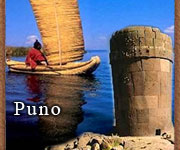
We offer different tourist attractions in the region of Puno as Titicaca Lake, Uros,taquile,Amantani,llachon,sillustani.
The lake is located at the northern end of the endorheic Altiplano basin high in the Andes on the border of Peru and Bolivia. The western part of the lake lies within the Puno Region of Peru, and the eastern side is located in the Bolivian La Paz Department.
The lake is composed of two nearly separated sub-basins that are connected by the Strait of Tiquina which is 800 m (2,620 ft) across at the narrowest point. The larger sub-basin, Lago Grande (also called Lago Chucuito) has a mean depth of 135 m (443 ft) and a maximum depth of 284 m (932 ft). The smaller sub-basin, Wiñaymarka (also called Lago Pequeño, "little lake") has a mean depth of 9 m (30 ft) and a maximum depth of 40 m (131 ft). The overall average depth of the lake is 107 m (351 ft) Lake Titicaca is fed by rainfall and meltwater from glaciers on the sierras that about the Altiplano. Five major river systems feed into Lake Titicaca.
In order of their relative flow volumes these are Ramis, Coata, Ilave, Huancané, and Suchez.[3] More than 20 other smaller streams empty into Titicaca, and the lake has 41 islands, some of which are densely populated.
Having only a single season of free circulation, the lake is monomictic, and water passes through Lago Huiñaimarca and flows out the single outlet at the Rio Desaguadero,which then flows south through Bolivia to Lake Poopó. This only accounts for about 10% of the lake's water balance. Evapotranspiration, caused by strong winds and intense sunlight at altitude, balances the remaining 90% of the water input. It is nearly a closed lake.
The cold sources and winds over the lake give it an average surface temperature of 10 to 14 °C (50 to 57 °F). In the winter (June-September), mixing occurs with the deeper waters, which are always between 10 to 11 °C (50 to 52 °F).
The origin of the name Titicaca is unknown. It has been translated as "Rock Puma ", allegedly because of its resemblance to the shape of a puma hunting a rabbit, combining words from the local languages Quechua and Aymara, and as well as translated as "Crag of Lead." Locally, the lake goes by several names. Because the southeast quarter of the lake is separate from the main body (connected only by the Strait of Tiquina), the Bolivians call it Lago Huiñaymarca (Quechua: Wiñay Marka) and the larger part Lago Chucuito. In Peru, these smaller and larger parts are referred to as Lago Pequeño and Lago Grande, respectively.
Islands in Titikaka lake:
Uros
Uros people harvesting some totora, an aquatic plant used to make their famous floating islands
Titicaca is notable for a population of people who live on the Uros, a group of 42 or so artificial islands made of floating reeds (totora, a reed that abounds in the shallows of the lake). These islands have become a major tourist attraction for Peru, drawing excursions from the lakeside city of Puno. Their original purpose was defensive, and they could be moved if a threat arose. Many of the islands contain watchtowers largely constructed of reeds.
Amantaní island
Amantaní is another small island on Lake Titicaca populated by Quechua speakers. About 800 families live in six villages on the roughly circular 15 square kilometres (6 sq mi) island. There are two mountain peaks, called Pachatata (Father Earth) and Pachamama (Mother Earth), and ancient ruins on the top of both peaks. The hillsides that rise up from the lake are terraced and planted with wheat, potatoes, and vegetables. Most of the small fields are worked by hand. Long stone fences divide the fields, and cattle, sheep, and alpacas graze on the hillsides.
There are no cars on the island and no hotels. A few small stores sell basic goods, and there is a health clinic and school. Electricity was produced by a generator and provided limited to a couple of hours each day, but with the rising price of the petroleum, they no longer use the generator. Most families use candles or flashlights powered by batteries or hand-cranks. Small solar panels have recently been installed on some homes.
Some of the families on Amantaní open their homes to tourists for overnight stays and provide cooked meals, arranged through tour guides. The families who do so are required to have a special room set aside for the tourists and must fit a code by the tour companies that help them. Guests typically take food staples (cooking oil, rice, sugar) as a gift or school supplies for the children on the island. They hold nightly traditional dance shows for the tourists where they offer to dress them up in their traditional clothes and participate.
Taquile Island
Taquile is a hilly island located 35 kilometres east of Puno. It is narrow and long and was used as a prison during the Spanish Colony and into the 20th century. In 1970 it became property of the Taquile people, who have inhabited the island since then (current population around 3,000). Pre-Inca ruins are found on the highest part of the island, and agricultural terraces on hillsides.
Isla del Sol, Copacabana, Bolivia
Situated on the Bolivian side of the lake with regular boat links to the Bolivian town of Copacabana, Isla del Sol ("Island of the sun") is one of the lake's largest islands. Geographically, the terrain is harsh; it is a rocky, hilly island. There are no motor vehicles or paved roads on the island. The main economic activity of the approximately 800 families on the island is farming, with fishing and tourism augmenting the subsistence economy.
There are over 180 ruins on the island. Most of these date to the Inca period circa the 15th century AD. Many hills on the island contain agricultural terraces, which adapt steep and rocky terrain to agriculture. Among the ruins on the island are the Sacred Rock, a labyrinth-like building called Chicana, Kasa Pata, and Pilco Kaima. In the religion of the Incas, it was believed that the sun god was born here.[citation needed]
During 1987-92 Johan Reinhard directed underwater archaeological investigations off of the Island of the Sun, recovering Inca and Tiahuanaco offerings. These artifacts are currently on display in the site museum of the village of Challapampa.
Isla de la Luna and Cordillera Real
Isla de la Luna is situated east from the bigger Isla del Sol. According to legends that refer to Inca mythology Isla de la Luna (moon in Spanish) is where Viracocha commanded the rising of the moon. Ruins of a supposed Inca nunnery occupy the oriental shore.
Suriqui
Suriqui lies in the Bolivian part of lake Titicaca (in the southeastern part also known as lac Huiñamarca).
Suriqui is thought to be the last place where the art of reed boat construction survives, at least as late as in 1998. Craftsmen from Suriqui helped Thor Heyerdahl in the construction of several of his projects, such as the reed boats Ra II and Tigris, and a balloon gondola. |


.png)
.png)